Enregistrez gratuitement cette image
en 800 pixels pour usage maquette
(click droit, Enregistrer l'image sous...)
|
|
Réf : T02402
Thème :
Terre vue de l'espace - Volcans (181 images)
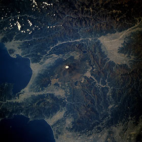
Titre : Mount Fuji, Honshu, Japan November 1985
Description : (La description de cette image n'existe qu'en anglais)
Snow-topped Mount Fuji, ringed by lakes and forests, is observable near the center of this low-oblique photograph taken over central Honshu, Japan. Mount Fuji, approximately 12 390 miles (3800 meters) above sea level, is located about 70 miles (110 kilometers) west-southwest of Tokyo. This volcanic peak, the tallest in Japan, is considered a sacred mountain by the Japanese. The snow-capped, symmetrical cone volcano, with a crater diameter of nearly 2 000 feet (610 meters), last erupted in 1707. The Fuji River flows west of Mount Fuji toward the interior where it passes through the city of Kofu, north-northwest of the volcano. Visible east-southeast of Mount Fuji is the Hokone caldera, which is 6 miles (10 kilometers) wide. The scene captured in this photograph is typical of the topography of the four largest islands of Japan—Hokkaido, Honshu, Shikoku, and Kyushu. Because the Japanese archipelago is volcanic in origin, less than 20 percent of the land is habitable, and farmland is limited and regionally fragmented.
|
|

